
Mission Possible
Guerrilla Cartography’s origin story
Undergraduate students in the 2011-12 cartography class at UC Berkeley’s Geography Department opted in to a group project to fulfill their final map requirement; to build an atlas of San Francisco’s Mission District in a joint project with Mission Local, a news site in the Mission District. A project of experiential and participatory mapping, the students spent field time alongside Mission Local reporters exploring the Mission and meeting its mélange of people and institutions that create a neighborhood. Aided by the reporters’ willingness to share sources and ground knowledge, the students chose subjects and phenomena that gave personal meaning to their maps. Their impressions, insights, and visceral experiences are represented in the twenty-one maps that make up the body of the atlas, Mission Possible: A Neighborhood Atlas.
Shepherding the process of a place-based thematic atlas by students expanded the scope and dimensions of cartography instruction, revealing possibilities of atlas narratives that are collaborative, creative, and experiential; giving rise to an atlas narrative that is rooted by, and to, the place itself. For the instructor, the experience also birthed a new and deeper meaning of mapmaking—that a map-or an atlas-could be for the place, not just of the place. And that by being for a place, data is democratized and an imperative to cache and share collective knowledge creates a social benefit.
By the end of the project in the spring of 2012, the idea to crowdsource an atlas from the global community for all the same reasons had been spawned. That summer, during the lull between semesters, the idea inspired a plan and a Call for maps was shared and re-shared among mapmakers, researchers, artists, and makers, through email, some nascent social media, and the blogosphere. Seeking a global community of collaborators, a concept rather than a place would be the theme of the atlas. Food. A one-word but multi-dimensional concept that is universal yet personal; a concept common to the world but uniquely individual. Send a map about food is all that was requested. No guidance and no suggestion. No direction and no boundary. A guerrilla mapmaking exercise.
A map often stands alone. It might have a home in a book full of words or a website of commerce, or nakedly masquerading as art on a wall. A map standing with other maps becomes an atlas and creates, with its comrades, its own home. But to find community this home of maps (the atlas) requires an audience to view, read, and be taught and told the story within the map—it requires to be published. And if the crowd who created the maps and those that gathered them together published the atlas and did it outside the conventional publishing space, it is disruptive. A guerrilla publishing exercise.
Guerrilla Cartography became the nexus for all the above. A globally crowdsourced atlas on the broad subject of food, globally crowdfunded to make it into a tangible material volume, globally free use and share copyright, for the purpose of giving maps (and mapmakers, researchers, and designers) a home, with the intent of knowledge-caching and -sharing the creativity and research, epiphanies and histories, imagination and intention, and ideas and ideals of the crowd who came together with a shared vision of a thing that could be.
Food: An Atlas was published and printed in January of 2013.
Guerrilla Cartography incorporated as a 501(c)(3) nonprofit in 2014 with the mission to widely promote the cartographic arts and facilitate an expansion of the art, methods, and thematic scope of cartography, through collaborative projects, hosting theme-based community workshops and symposiums, and mounting public exhibitions.
Water: An Atlas was published in 2017.
Atlas in a Day: MIgration was published in 2019.
Atlas in a Day: Community was published in 2020.
Shelter: An Atlas was published in 2023.
Guerrilla Cartography is currently planning an education Initiative to be launched in 2024.
Mission Possible: A Neighborhood Atlas
Mission Possible: A Neighborhood Atlas was published in 2012 by Mission Local, a hyper-local journalism lab centered in the Mission District and founded by Lydia Chavez, Professor Emeritus, UC Berkeley Graduate School of Journalism.
Editors and faculty advisors: Darin Jensen and Lydia Chavez. Assistant editor: Molly Roy.
atlas cover

title page with graduating inset locator maps

contents page with a program description and short essay on map orientation

map 1. Mission: Saturday sounds
-Aaron Dobie

map 2. Mission: Carspace
-Serena Nitta
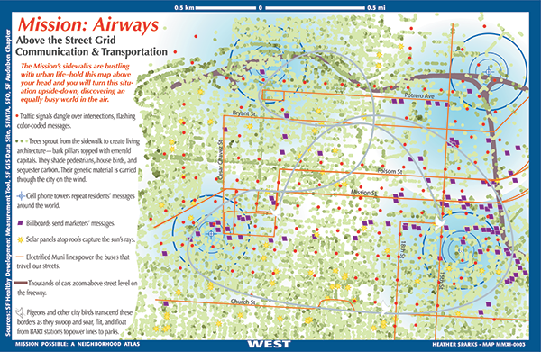
map 3. Mission: Airways—Above the street grid communication & transportation
-Heather Sparks

map 4. Mission: Creek—Historic and future waterways in the Mission District
-Heather Sparks
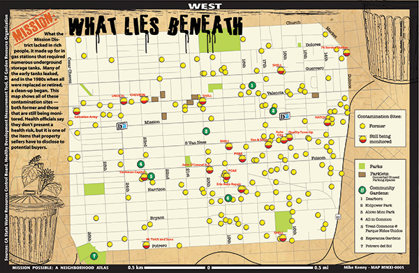
map 5. Mission: What lies beneath
-Mike Kenny

map 6. Mission: A stronger you!!
-Chris Fuentes

map 7. Delores Park: From burial ground to open market
-Serena Nitta

map 8. Mission: Congregating
-Alex Z Cole-Weiss

map 9. Mission: Missed connections and the moon—March-April 2011
-Claire Sarraillé

map 10. Mission: Gangs and cupcakes
-Danya Al-Saleh

map 11. Mission: Coffee buzz
-Allison Barden

map 12. Mission: Food—Stars and saints
-Paige Enoch

map 13. Mission: Makers
-Alex Z Cole-Weiss

map 14. Mission: Free—Living free in the Mission, resources for the frugal
-Andrea Butkovic

map 15. Mission: Sustainable
-June Thammasnong

map 16. Mission: Housing—Low- and no-income
-Claire Sarraillé

map 17. Mission: Hispanic population change—2000-2010
-Trish Allred
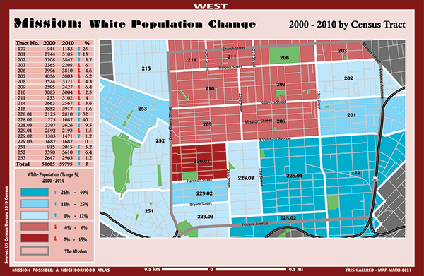
map 18. Mission: White population change—2000-2010
-Trish Allred

map 19. Mission: Black population change—2000-2010
-Trish Allred

map 20. Mission: Asian population change—2000-2010
-Trish Allred
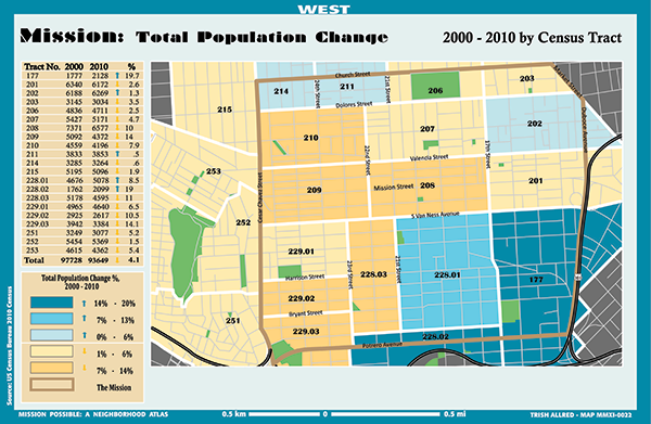
map 21. Mission: Total population change—2000-2010
-Trish Allred
notes and acknowledgements

publisher’s page
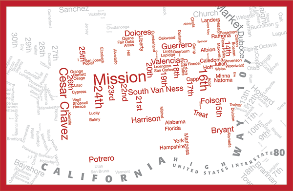
atlas back cover | mission district street cloud
-Darin Jensen
Guerrilla Cartography thanks Lydia Chavez and Mission Local
for allowing the display and free pdf download of Mission Possible.
You can read more about the history of Guerrilla Cartography
and learn about our board members at the ABOUT US page.